Topography
Physical Data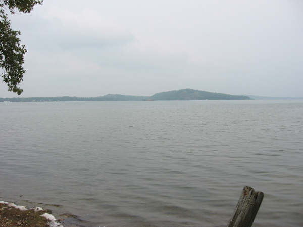
Latitude - 45.26 Longitude - 77.12 Surface Area - 4275 acres (1730 hectares) Volume - 156,500 acre feet (193,039,910 cubic metres) Height Above Sea Level - 755 feet (230m) Perimeter - 19.6 miles (31.5 km) Maximum Depth - 140 feet (42.6m) Mean Depth - 36.6 feet (11 m) Lake Clear is situated on the southern edge of the Ottawa-Bonnechere graben rift valley. Along its south shore is the escarpment of Mount St. Patrick fault. Of all the Bonnechere watershed lakes, Lake clear has the second longest shoreline at 46 km. The lake is situated on Precambrian rock. Hurd's Creek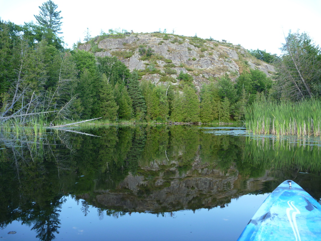
The creek between Lake Clear and Little Lake Clear is one of the best paddling spots around. It is a great place to count painted turtles and is one of the most prolific snapping turtle sites in the Bonnechere watershed. You will see many water lilies and cattails there, also.
For more detailed info: https://sites.google.com/site/lakeclearnaturalheritage/hurds-creek-dam Hurd's Creek Catchment Report |
Lake CharacteristicsThermal stratification was evident at the time the lake was surveyed. Water Temperatures dropped from 74F degrees to 52F degrees between the twenty-five and forty-five foot depths identified the thermocline (the layer of water in which there was the most rapid decrease in temperature). The dissolved oxygen content varied slightly from 8.0 parts per million at the surface to 6.0 parts per million at seventy-five feet. The mean 7.8 ph value showed an alkaline characteristic in relation to the hydrogen ion composition of the water. A total dissolved parts concentration of 144 parts per million was determined from conductivity readings. Clarity in this blue coloured water was indicated by the disappearance of the secchi disk from view twenty feet below the water surface. Water levels are controlled by the Renfrew Hydro Electric Commission, http://www.renfrewhydro.com/, dam at Hurd's Creek.
Big Rock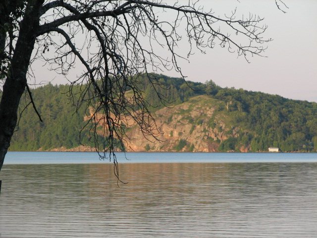
Big Rock is possibly the most recognizable landmark on the lake. It is located on the northeast shore. It is a peregrine falcon nesting site. In the afternoon sun, when the shadows are just right, it resembles an Indian head.
Group of Seven painter, A.Y. Jackson painted Big Rock among his many landscape portraits of this area. A trail commemorating this and other locations, and paying tribute to local artists, has been established: www.ayjacksontrail.ca. |
Physiography of the Area
This information was provided by John Almstedt.
The physiography of the area reflects profound geological events that can be traced back for more than one billion years.
The physiography of the area reflects profound geological events that can be traced back for more than one billion years.
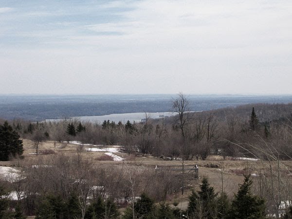
Lake Clear View from Ryan Mountain
The high hills adjacent to the lake mark the trend of the ancient Petawawa fault along the western side of a rift valley running 435 miles from Montreal to near Sudbury. This rift valley was formed when the Earth's crust subsided about 1/2 mile (805m) between the Mattawa Fault (which follows the Ottawa River) and the Petawawa Fault.
Just south of the Petawawa Fault, Foymount's Ryan Mountain at 1716' (523m) is the highest peak in Renfrew County.
Just south of the Petawawa Fault, Foymount's Ryan Mountain at 1716' (523m) is the highest peak in Renfrew County.
No Ordovician strata have been found in the Lake Clear area (nor should there be any, since the area south of the Fault is within the uplifted block of Precambrian rock)
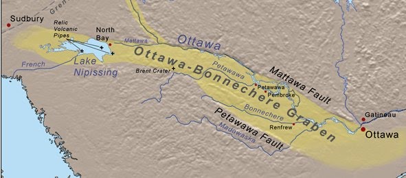
The Petawawa and the Mattawa Faults are two of many normal faults that define the Ottawa Valley. The Ottawa Rift Valley, also referred to as the Ottawa-Bonnechere Graben initiated more than 570 mya (million years ago) during the Precambrian Eon when the first mult-celled animals began appearing. The faults along both margins are still active, occasionally releasing stress in the form of earthquakes.
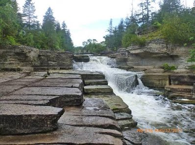
4th Chute
During the Ordovician geologic time Period, 510 to 440 mya age, when North America was under shallow seas, the first corals, primitive fishes and a variety of other sea life emerged which today can be found as fossils in the rocks around the 4th Chute and elsewhere along the Bonnechere River (See Bonnechere Caves).
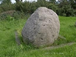
Erratic boulder derived from Ordovician limestone within the Ottawa-Bonnechere Graben, transported southward by the continental ice sheet during Pleistocene glaciation
During the Pleistocene Epoch (2.5 mya to 12,000 years ago) glaciers covered the area completely, leaving a significant imprint on today's landscape in the form of sandy soil, marine clay and and large boulders.
The margins of ancient glacial and post-glacial lakes are recorded by successive raised, step-like beaches and wave-cut terraces at various elevations. The sand and gravel around the Sand Rd. waste transfer depot is an example of glacial sand deposits.
The margins of ancient glacial and post-glacial lakes are recorded by successive raised, step-like beaches and wave-cut terraces at various elevations. The sand and gravel around the Sand Rd. waste transfer depot is an example of glacial sand deposits.
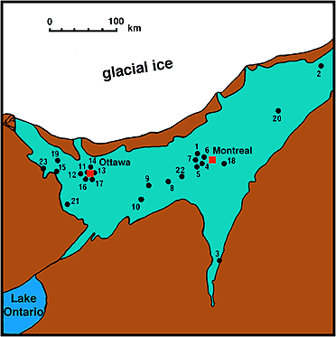
Outline of Lake Champlain at its maximum state, when the front of the continental ice sheet had retreated to the approximate position shown, just north of the present-day Ottawa River. Sites at which skeletal remains of whales have been recovered are shown by numbers (refer to Champlain Sea fossils
After the glacial retreat 12,000 years ago the Atlantic Ocean flooded the Ottawa-Bonnechere Graben forming the Champlain Sea. The unconsolidated marine sedimentary deposits of shell-rich sand and clay are related to this period. Remnants of salt from the sea still affects some of the wells in the region.
Additional information on glaciers and the Champlain Sea's effect on the Ottawa Valley can be found on McElroy's Glaciation of the Ottawa Valley.
Additional information on glaciers and the Champlain Sea's effect on the Ottawa Valley can be found on McElroy's Glaciation of the Ottawa Valley.

|
|